Deaderick Street is an urban core streetthat serves as a physical connector between the city/county courthouse and the state legislature. This street was a central transfer point for the Metro bus system. It was filled with empty bus shelters, had no trees, and had a storm water and sewage overflow problem. However, the street was transformed into one of the most sustainable and livable streets in the downtown area in 2009, one year after the city decided to relocate the bus system’s hub one block. Now the streetscape has 102 trees, 4,249 shrubs and perennials and all LED lights.
Adopted from: Jenny Burns 2009, Nashville Business Journal
Hawkins Partners, Inc., worked with the Office of the Mayor and Metro Public Works to transform the historically and civically significant corridor. Deaderick Street is situated within the Kerrigan Basin, one of Nashville’s Combined Storm Sewer basins, where had overflow problems. The project primarily focused on addressing storm water issues and urban trees. Based on Nashville’s historical rainfall patterns, infiltration rates and variable design factors, it is estimated that over 1.2 million gallons will be removed from the CSO system on an annual basis through this three block urban street (Hawkins).
Adopted from: Jenny Burns 2009, Nashville Business Journal
Project Highlights Who: Metro Nashville Public Works When: October 2008 to October 2009 General contractor: Roy T. Goodwin Contractors, Nashville, TN Landscape architect: Hawkins Partners Inc., Nashville, TN Project budget: Under $5 million ($3.1 million in capital improvement funds)
Provided a 700% increase in pervious area (diverting approximately 1.2 million gallons of storm water from the Cumberland River per year).
Incorporated bioswales (Rain gardens) at sidewalk level planting areas and at street level to capture, filter and infiltrate rainwater.
Used porous concrete used to allow water infiltration through sidewalk to tree root zones.
Planted 102 4-inch caliper shade trees, and 4249 shrubs, perennials, sedges, and groundcover plants.
Native plants comprise 53% of the species installed.
Some healthy, existing street trees were transplanted.
Other elements included:
Irrigation: low flow nozzles (33% less water), drip system and soil moisture probe.
Pedestrian streetlights and guidance signs are LED.
LED traffic signals.
Solar-powered parking meters.
Recycled, crushed concrete used for sub-base for concrete walks.
High percentage recycled steel used in pedestrian light poles, tree grates, fence, trash/recycling containers, pedestrian guidance signs.
Recycled coal fly ash within the concrete.
Bicycle storage facilities.
Educational kiosks that explain the benefits of urban trees, rain gardens, and sustainable infrastructure.
This plan also focused on creating a multipurpose environment that would draw people in. The long-term master plan proposed additional development potential of 40,000 square feet of retail and restaurant uses, 11,000 square feet of office use, and 94 residential housing units. The street can be a venue for occasional events and festivals. The removal of the transit mall reduced average daily traffic volume, creating a more pedestrian-friendly environment and providing more on-street parking. Yet, business owners share differing opinions. There is an increase in tourists with concerts and other events to the street. But some owners said business was better when the bus transit center was there.
Adopted from: Elizabeth Johnson, The Tennessean
Potential Benefits:
Promotes sustainable and livable streets through low-impact design.
Generates less traffic and thus more pedestrian-friendly environment.
Brings tourism money to the downtown area through events and festivals.
Prevents water sewage problems.
Implements the plan block-by-block to allow as much of the street as possible to remain open during construction.
Serves as one of four Tennessee projects to be accepted as pilot projects for The Sustainable Sites Initiative (Johnson 2010).
Potential Issues:
Business impact: The relocation of the transit center had a negative impact on businesses in the area.
Code and regulation amendments: Amendments may be required to allow more street activities like outdoor dining (Hawkins).
Insadong-gil is a great example of a shared road that respects its historic past while meeting the changing needs of modern street users. It is a narrow road in Insadong, a historic neighborhood in Jongno-gu District of Seoul in South Korea. The district is bordered by Gwanhundong to the north, Nagwon-dong to the east, and Jongno 2-ga and Jeokseon-dong to the south, and Gongpyeong-dong to the west. The street is only approximately 0.4 miles long and 33 feet to 49 feet wide. Along the street, there are a multitude of antique shops, traditional paper shops, galleries, cafes and restaurants. The three lines of Seoul Metro (subway) and free shuttle buses connect the area to other destinations.
The Insadong has a long history. It was originally two towns whose names ended in the syllables "In" and "Sa." They were divided by a stream which ran along Insadong's current main street. It began 500 years ago as an area of residence for government officials. During the Japanese occupation, the wealthy Korean residents were forced to move and sell their belongings. The site became an area for trading in antiques. It was a popular destination among foreign visitors to South Korea during the 1960s, who called the area Mary's Alley. In 1988, it became a historic and cultural street. To keep the traditional Korean feel of Insadong intact, the city allows only certain types of businesses in the area. Most of these older buildings are now used as restaurants or shops. Among the historically significant buildings located in the area are Unhyeongung mansion, Jogyesa, one of the most significant Korean Buddhist temples, and one of Korea’s oldest Presbyterian churches.
From 1999 to 2000, the City redesigned the street as an unique corridor for experiencing history and culture. For the street section north of of Insadong 5-gil, the asphalt pavement was replaced by traditional Korean black tiles. The flush 'curbless' road was maintained by replacing ugly cement roadblocks with elegant granite slabs, thereby demarcating a clear path of travel for automobile. The granite paving for the automobile way is rougher and stands in the contrast with the more polished texture that is primarily used by pedestrians, temporary parking and for loading and unloading services. New trees with planters and additional seating help create comfortable areas for sitting and gathering.
The section south of Insadong 5-gil continues most of the pedestrian friendly features including trees in planters, granite slabs for seating and Korean black tiles for sidewalk paving. However, the automobile way has asphalt surface and separated from the formal sidewalk by a small curb. Most of the street is a one way street open to automobile traffic. The entire street is closed to traffic on Sundays. The two ends of the street are defined by venues for social gathering and performances as well as information centers for tourists. Overall, the street was redesigned to allow for more festivals such as the six day annual Insa festival, that would attract both locals and tourists. To further beautify the neighborhood, old and unsightly utility poles were removed with floral containers. The widened sidewalks, traditional pavement and the narrower vehicle road have made the Insadong-gil more pedestrian-friendly.
One of the key elements that imbues the street with a unique identity is the custom designed signage and seating. The street furnishings celebrate the mix of of historical and modern architecture that can be seen along the street. Wide variety of seating fixtures exist. Engravings in the seating tell stories of the its past historic past. Art is also integrated in the design of gateways, seating, planters and fountains.
Insadong is the place where 40 percent of the nation’s antique shops and galleries as well as 90 percent of the traditional stationary shops are located. This place is also famous for traditional tea and Korean food, which enhance the sensory experience of the locals and tourists. A multitude of street performances by artists makes the street experience memorable. There are daily calligraphy demonstrations and pansori performances of traditional Korean music. This formal and informal programming of street life helps strengthen its ability to remain an identifiable street.
Adopted from: Insadong
Lessons Learned Potential Benefits:
Creates a pedestrian-friendly environment with the widened sidewalk, narrowed road, lined trees and public seats, providing a pleasant walking experience.
Enlarges the pedestrian realm by closing the street to traffic every Sunday.
Creates a unique streetscape that provides a sensory experience as well as historic experience of Korea with artistic street performances, galleries, and the antique shops in the historic buildings.
Potential Issues:
Restriction on the type of businesses: Even though the city restricts the sprawling of Western chains, the street has become more tourist-oriented, losing its personality because of an excessive number of souvenir shops and other tourist-oriented businesses.
Pedestrian traffic: Since the Insadong-gil is one of the most popular streets in Seoul, especially on the weekend, it is difficult to maneuver one’s way through the crowd. Some people may enjoy being in the crowd, but some may find it unpleasant.
Shared streets: During the weekdays, the through traffic and illegally parked cars makes the narrow road even busier, disrupting pedestrian flow.
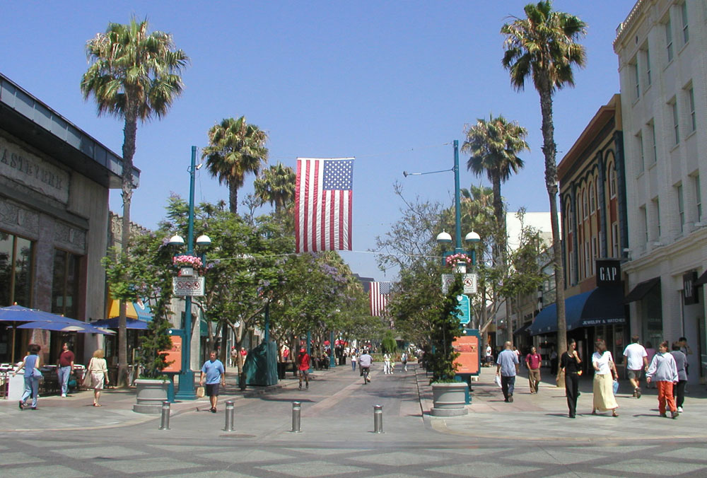
The Third Street Promenade is one of the few successful pedestrian malls in USA. This grand mixed-use entertainment venue is about 0.4 miles long. Located in Downtown Santa Monica, the three blocks of the Promenade lie between Broadway and Wilshire Boulevard. Due to its proximity to the Pacific Ocean coupled with Los Angeles's mild climate, it has been a popular tourist destination.
There are more than 60 stores as well as 25 restaurants, cafes and casual dining places on the Promenade. Besides great shopping and dining, the area has many entertainment alternatives, such as movie theaters, venues for performances, clubs and bars.
One of the biggest entertainment attractions of the Third Street Promenade is the eclectic mix of street artists and performers. The Downtown Santa Monica Farmers’ Markets is located at the Promenade on Wednesday and Saturday. There are public parking structures on 2nd and 4th Streets between Wilshire Boulevard and Broadway, and one structure just north of Wilshire on 4th Street.
The Third Street Promenade was a typical street with automobile traffic. In1965, the City converted it into a pedestrian mall called the Santa Monica Mall. In 1984, the Santa Monica City Council created a city-funded nonprofit agency called the Third Street Development Corporation, now Downtown Santa Monica, Inc. (DTSM, Inc.), to revitalize the area. With a citywide bond measure issued in 1986, the mall was redesigned and renamed as the Third Street Promenade. A new shopping center, Santa Monica Place, designed by Frank Gehry, was built at the Promenade's southern end. Third Street Promenade opened in 1989, redesigned by the architectural firm ROMA Design Group. The City also created the Third Street Promenade and Downtown District assessment fee. Funded by tenants within the district, it generates approximately $13 million per year for Promenade management.
The Third Street Promenade is an approximately 70-foot wide and lined with trees, shops, kiosks, public art pieces and benches. Shop owners initially felt that preventing cars from accessing their front doors was destroying their business. As a result, the City constructed a road through the Promenade, but placed removable bollards at the ends of each block. Eventually, the street was closed. Now Third Street competes with local shopping centers by providing a festive pedestrian space protected from auto traffic in the heart of downtown Santa Monica, and is a frequent destination for tourists visiting the Los Angeles area (Rawson).
In 2007, the city proposed the Property-Based Assessment District to revitalize the downtown area. It included a wide range of projects, such as enhanced maintenance, new ambassador services, initiatives to reduce homelessness, parking improvements, congestion mitigation, infrastructure updates, marketing, new resource commitments from both the public and private sector, and a new balanced governance structure for Bayside. The old Santa Monica Place, which was a struggling indoor mall, was renovated into an outdoor luxury shopping center by Dallas-based Omniplan. It reopened on August 6, 2010.
Adopted from: Downtown Santa Monica 2008
Lessons Learned Potential Benefits
Pedestrian-prioritized street with a great variety of outdoor living rooms and social gathering places.
A great attraction for people working locally to linger when they want to miss rush hour traffic jams (Moosbrugger 2008).
Well designed street that maximizes the existing natural context by creating sunny open spaces where people can watch the Pier and feel the ocean breeze.
Potential Issues
Tourism: The businesses depend on tourism from the outside of the region, which is easily affected by the world economy or high gasoline prices (Moosbrugger 2008).
Identity: The Promenade have been criticized for loosing its personality by opening homogenized stores and restaurants. However, some feel that the redesigned promenade has created a new identity distinctive to Santa Monica
Traffic: Neighbors are concerned about traffic congestion along Santa Monica Boulevard, Wilshire Boulevard and Arizona Avenue, and about overcrowded parking structures.
Local needs: The high-end shops in the renovated Santa Monica Place are also criticized by the locals as not serving the neighbor’s needs(Chang 2010).
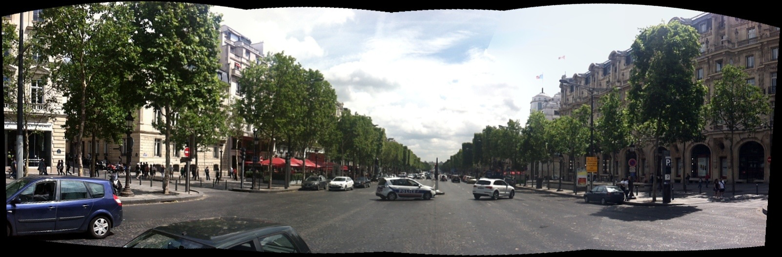
The Champs Elysees is the thoroughfare that runs through the heart of Paris and links the southeast to the northwest of Paris. It is a 1.2-mile long and 230-foot wide major road that runs from Place de la Concorde to Arc de Triomphe (Paris Digest). The avenue consists of two different sectors: the intensely developed northern part, from the Rond-Point to the Place de I’Etoile, and the well-landscaped southern part, from the Place de la Concorde to the Rond-Point. This grand boulevard has approximately 70-foot wide sidewalks (which sometimes include 22-foot wide access roads) and double rows of street trees to buffer pedestrians from traffic. But crossing 10 travel lanes (approximately 87 feet) is challenging for pedestrians. The average daily traffic volume is about 84,000, with an average of 10.67 accidents per year per intersection (Jacobs1994).
Because of its proximity to several Paris landmarks such as the Arc de Triomphe, the Champs Elysees has been a venue for several famous military parades and public events. On Bastille Day, the largest military parade in Europe passes down the Champs Elysees. Each year from the end of November to end of December, the Champs Elysees Committee contributes to the lighting of the Champs Elysees for the holiday season.
Adopted from: History of Avenue des Champs Elysees
The Champs Elysees originally consisted of market gardens, fields and swamplands on the outskirts of Paris. In 1616, Marie de Medici, a queen consort of France, decided to extend the garden axis of the Palais des Tuileries (a royal palace in Paris) with an avenue of horse-chestnut trees. In 1724, the Tuileries garden axis and the avenue were extended, leading beyond the Place de l'Etoile. By the late 1700s, the Champs Elysees had become a fashionable avenue and the trees on either side had thickened. In 1828, the Avenue des Champs Elysees became city property, and sidewalks, fountains and street lighting were added. By the 1860s, when Baron Georges Eugene Haussmann was giving Paris its present shape, the Champs Elysees had become a center of cafes, hotels and luxurious homes. However, the prosperity of the 1960s attracted airline companies, car dealerships, fast-food restaurants, panhandlers and badly parked cars. Rents plummeted and many commercial spaces stayed empty.
Adopted from: Riding 1990
In 1990, Jacques Chirac, the mayor of Paris, began a $45 million project to redevelop the historic zones and public spaces. According to Barbe, the aim of the redevelopment was to “renew a grand promenade popular with Parisians, the French people and foreigners by once again giving it an urban quality, a dignity and a life which it had lost (Barbe 1995).”
The main elements of the redevelopment of Champs Elysees included (Pearce 1998):
Enhancing the perspective of the avenue by removing curbside car-parking and creating a new 850-space underground car park.
Widening the sidewalks.
Planting a second row of trees.
Reducing and realigning the street furniture, such as streetlamps and bus stops.
Upgrading the shop frontages by new regulations governing publicity, signs and terraces.
Changing the land use zoning (plan d’occupation des sols) to encourage the return and development of such functions as hotels and cinemas that generate some of the activity for which the avenue was previously known.
What Makes Champs Elysees a Great Place?
Comfort and Image
Extra-wide sidewalks provide adequate space for cafes and vending.
Continuity of trees and lighting scales down the expanse of the sidewalk.
The alley of trees along the curb buffer pedestrians from the automobile traffic.
There are few benches on the Champs Elysees, but many restaurants and cafes provide outdoor seating.
Plantings, coverings and shade enhance outdoor seating experiences.
Sidewalk amenities include colorful banners, cast-iron kiosks with displays, ornate street lamps and interesting sidewalk patterns.
Uses and Activities
Most people walk on the sunny northside, where there are more cafes, theaters, chain stores and boutiques.
Fewer stroll on the south, where there is less sun and more banks and luxury restaurants.
Activity does not decline after dark; the street is well-lit and takes on a new ambiance of nightlife.
Adopted from: Project for Public Spaces
Shopping and Tourism
The Champs Elysees is a great 30-minute walk from Champs Elysees Clemenceau metro station (line 1) to Arc de Triomphe and Charles de Gaulle metro station (line 1). It is also the top Paris shopping district with 500,000 visitors daily. Many famous French and international brands have their flagship stores along the corridor. There are luxury shops and hotels, such as Cartier, opened in 2003, Louis Vuitton’s five-story flagship store, and the Fouquet’s Barrière hotel, where the least expensive room is nearly $900 a night. Louis Vuitton is so popular that its customers — most of them tourists — often line up outside for entry (Sciolino 2007).
The Champs Elysees is one of the most expensive avenues in the world, and this causes a loss of small, local stores in the area. With rents as high as $1.2 million a year for 1,000 square feet of space, the Champs Elysees is the most expensive strip of real estate in Europe, and the third most expensive in the world after Fifth Avenue in New York and Causeway Bay in Hong Kong (Sciolino 2007). As such, only global chain stores can afford the rent, and most of the music clubs and movie theaters are closing. The avenue progressively is losing its exceptional and symbolic character, thus its attractiveness. The City tries to push back by stopping the opening of international stores and providing annual subsidies for old, local businesses. For example, the H&M clothing chain was not permitted to open a store on the Champs Elysees in 2007.
Lessons Learned Potential Benefits:
Increases the city’s tourism industry.
Enhances the pedestrian experience. The double rows of trees, widened sidewalks, outdoor seating and cafes on the sidewalk contribute to memorable walking experience.
Provides for safe nightlife. The street is well-lit and creates a new ambiance of nightlife.
Potential Issues:
High rents: The continued success of the street has led to high rents, which is causing the loss of its small businesses and thus the street’s original identity.
Maintenance: The street requires constant maintenance to keep the corridor safe and clean. Police officers and street cleaners keep eyes on the street to make it safer for its visitors and compensate for a lack of trash cans.
Street crossing: Crossing wide, heavy trafficked roads is challenging for pedestrians.
Shade vs. visibility: The London plane trees, spaced at about 30 feet, were pruned too high above ground level, and thus do not provide appropriate shade and visual protection from the traffic. However, they do allow greater visibility of businesses.
Pedestrian access: The outdoor dining and kiosks on the sidewalk sometimes block the pedestrian flow.
Sources
Barbe, C., 1995. “La Rehabilitation des Champs Elysees (mimeo).” Paris: Direction de l’Amenagement Urbain
Originally a predominately Italian fishing neighborhood, Little Italy is a thriving neighborhood in Downtown San Diego, California. The scenic neighborhood includes Italian restaurants, Italian retail shops, home design stores, art galleries and residential units.
A fairly easy walk, San Diego's Little Italy is over 48 square blocks filled with rich Italian culture, which allows visitors to absorb the people, sights and overall atmosphere. India Street, the thriving commercial corridor, runs straight through heart of Little Italy, intermingled with high-density mixed-use buildings and single-family bungalow-style historic properties. A trolley provides easy connection between Little Italy and the Santa Fe Train Depot, the American Plaza trolley transfer station and the Old Town Transit Center. Little Italy is located in close proximity to San Diego International Airport.
Historically, Little Italy was the home to Italian fishermen and their families. Many Italians moved to San Diego from San Francisco after the 1906 San Francisco earthquake in search of tuna and other deep-sea sport and commercial fish. When Interstate 5 was constructed through Little Italy in the early 1970s, 35% of the neighborhood was destroyed. During the same time, the California tuna industry was declining, which caused the neighborhood to suffer nearly 30 years of decline. At that time, the neighborhood was mainly composed of low-density commercial businesses and single-family detached homes.
With the creation of the Little Italy Association in 1996, the neighborhood has gone through gentrification and has seen a renaissance as a Community Benefit District. Its Italian food, boutique shopping and high level of street maintenance makes this shopping district the place to live in Downtown San Diego. Currently, the neighborhood is mainly composed of residential units – mostly mid-rises, high-rises and lofts – with ground floor retail stores and a few commercial buildings.
There are multiple public improvements and high-rise and mid-rise buildings under construction or scheduled for construction. Although many of the buildings have been renovated, the new buildings duplicate the same feel of the original establishments with huge archways, outdoor dining and ample vegetation that make visitors feel as though they have walked straight into Italy. During special events, many family-owned restaurants let visitors try their specialties. All along India Street, public art and various Piazzas invite visitors to stop and take in the San Diego sun.
Revitalization
Formation of a Business Improvement District (BID) during the 1990s, run by the private, nonprofit Little Italy Association, was a key factor in the area’s rebound. The association also runs a Community Benefit District (CBD). The Business Improvement District is funded through business tax licenses in the area and generates $90,000 a year. The Community Benefit District generates $750,000 a year through property assessments. The money from the BID and the CBD are used for maintenance and neighborhood security.
From eleven Italian-related businesses in the mid-1990s, Little Italy has grown to become home to 19 Italian restaurants, 22 home furnishing stores and 11 art galleries. The Centre City Development Corporation (CCDC) provided more than $4 million for many of the capital improvements to the streetscape. Improvements included upgrade and replacement of existing surfaces with particular sensitivity to retaining the original character along India Street, landscape, lighting and parking improvements as well as traffic circulation improvements and upgrades. The Little Italy Association provides maintenance funding for the trees, trashcans, landscaping and new sidewalks. The CCDC has also subsidized construction of 16 row houses, 12 affordable rental lofts and 37 low- and moderate-income apartments on a block of land the CCDC purchased. Currently the most common complaint is that an area once covered with parking lots is now one of the most difficult places to park in all of San Diego.
Adopted from: Shigley 2008
Other improvements have included:
Revitalizing the C Street corridor from India Street to Park Boulevard to make it safer for pedestrians, more conducive to private development and business, and more efficient for trolley riders.
Implementing the Trolley Renewal Project that focuses on repairing the nearly 30 year-old Blue and Orange lines, which are well beyond their life expectancy. The project includes installing low-floor trolleys, tracks and station platforms; replacing old rail and overhead wire; and improving switching, signaling and crossovers. The complete overhaul of transportation and pedestrian traffic flow is expected to be completed by 2015.
Developing the Piazza Basilone at the southeast corner of Fir and India, which will transform half of Fir Street into the Piazza. The Piazza is strategically located at the bottom of Fir Street, allowing the street to be closed off for special events.
Creating Amici Park, an approximately 50,000 square foot park in a formerly blighted corner of downtown bounded by Date Street and Interstate 5. The park is now shared by the community and Washington Elementary School.
Establishing a parking district that allows meter fees to be retained to benefit parking projects in Little Italy. Over 20 years, this revenue is anticipated to be almost $2 million.
Community Events
Year-round community events are held in Little Italy, and the majority are related to Italian culture. Most of the events center on and around India Street, usually bordered by Grape Street to north and Beech Street or Ash Street to the south. Some of these include:
Little Italy Mercato: An Italian farmers’ market held every Saturday on Date Street features freshly caught fish, vegetables and fruit from local farmers, pastries from local bakeries and art from Little Italy’s artists.
Little Italy Carnevale: A Venetian mask event held before Mardi Gras with entertainment and an open house for retail shops and restaurants.
ArtWalk: The largest art event on the west coast is held each April with over 120,000 people attending. It includes art, jewelry, furniture and more.
Gran Fondo (Big Ride) Colnago San Diego: Over 3,000 bicycle riders from all over the world come to ride throughout “America’s Finest City” in a 32-, 53- or 100-mile ride that starts under the Little Italy’s landmark sign.
Labor Day Stickball Tournament: Several stickball leagues come to play on the streets of Little Italy in this time-honored east coast game that is played like baseball. Every three years, the San Diego leagues host a West Coast Invitational where they invite New York and Puerto Rico to play on the streets of San Diego’s Little Italy.
Little Italy Festa: The largest Italian festival outside of New York City occurs in Little Italy in October. It includes over 150 Italian food and craft booths, three stages of entertainment, the Gesso Italiano Street Painting Festival, a stickball exhibition game, bocce ball tournament, and beer and wine gardens.
Little Italy Christmas Village and Tree Lighting: This holiday event occurs each December.
In addition, a number of food events, such as Festivale Siciliano and a Taste of Little Italy occur throughout the year.
The Italian Community Center of San Diego, a 500 member nonprofit organization founded in 1981 for people interested in Italian culture and language, also is located in the Little Italy neighborhood.
Lessons Learned Potential Benefits:
Leverages dedicated funding sources to implement improvements and provide maintenance.
Builds on the neighborhood’s historic character.
Utilizes mixed-use development to create a constituency for services.
Expands pedestrian and social gathering spaces.
Provides good linkage to transit.
Hosts unique year-round events that are primarily tied to the neighborhood theme.
Potential Issues:
Phased improvements: The neighborhood required improvements which were phased-in over several years.
Community support: The support of businesses and the community is needed.
Shigley, Paul, October 29, 2008. “In Shadows Of Downtown, SD’s Little Italy Thrives Again”
California Planning and Development Report (http://www.cp-dr.com/node/2169)
Share-it-Square is at Sherret Street and 9th Avenue in the Sellwood Neighborhood of Portland, Oregon. It was first constructed in 1996 for $65. Changes and improvements are ongoing.
Share-It Square was the first community-initiated and community-built project in Portland. When a group of Sellwood neighbors began building an unauthorized gathering space, a Portland city official’s response was, “That”s public space. Nobody can use it.”
Local residents, including Mark Lakeman, who went on to start City Repair, a local nonprofit that helps citizens design and build social gathering spaces in their neighborhoods, were primarily responsible for the design and implementation of this project.
“Our cities and places are no longer ours. We’re not building our own places; we’re not designing them to fit our own needs. Our lives are zoned like we’re a resource to be managed. We're housed here, and then this is where we work in order to pay for the housing we barely get to live in. Mixed use here. Monocultural use here. Parking garage. Maybe a waterfront here. Park. Park. It doesn't add up. None of them are really whole.” – Mark Lakeman.
The neighbors chose to transform an intersection, because a crossroads is a gathering place where people come together. “In America, our great archetype is the main street, which is not really a center. It’s just a flow. It’s a movement corridor, and you have to yell across the street because there isn’t a place in the middle. There isn't a social commons that you can attain and occupy.”
During the first project, the neighbors who lived around the intersection came out on the weekend, painted a design in the street, built all the structures around the corners–a bench, a lending library, a 24-hour tea stand, a children’s playhouse, a kiosk for sharing neighborhood information–and turned the intersection into an interactive social space.
Since then people have built saunas, put in gardens and helped each other paint their houses. Americans move every four to seven years, and that period of time is visibly lengthening right around that intersection because people want to live there. Families are clustering around it, having kids or bringing their kids, increasing the number of children in the neighborhood. There is more shared childcare and more adults interacting with kids on the street.
“New projects emerged over the years, as the intersection got repainted for about $500, which was raised by residents. People worked together. One neighbor built an earthen oven in the shape of her Australian tree frog, Oblio. It gets fired up for neighborhood pizza parties. Several neighbors went door to door and took 60 to 70 orders for fruit trees, huckleberry bushes, and other edible plants that will make the neighborhood a “fruitopia,” perfect for “grazing” as people walk through it.” – Mark Lakeman
Creation of the Square led to city adoption of the ordinance that allowed similar projects to be created. Portland’s ordinance requires that 80 percent of neighbors within two blocks sign statements approving the plan. After installation of Share-It Square, organizers surveyed their neighbors and found that an overwhelming majority (over 85% in each case) felt that crime had decreased, traffic had slowed and communication between neighbors had improved.
Sunnyside Piazza
Background
The Sunnyside Piazza is located at SE 33rd and Yamhill Street in Portland, Oregon. It was first constructed in 2001, built by local residents and City Repair.
In 2001, neighbors were complaining of noise, speeding, drugs, and abandoned cars. After a series of meetings and workshops facilitated by City Repair, they determined to paint a sunflower in the middle of the intersection, turning it into a piazza. One neighbor provided 28 gallons of paint. The city's street sweepers cleaned the intersection. Planter barrels were placed on either side of the four corners to keep people from parking in the piazza and to slow traffic down. Neighbors had a community gathering, complete with dancing and a visit from the winged T-Horse.
The next year, the city approved plans for trellises on all four corners, the first arches built over sidewalks in Portland since the stone gateways to Laurelhurst Park some 100 years ago. One neighbor, who had initially opposed the painting of the intersection, came up with the idea to plant honeysuckle in the trellises. Neighbors raised the money and did the work.
There have been a few acts of vandalism, but nothing serious. “Some kids have ‘laid rubber’ in the middle of our intersection, there’s often litter and one time someone pulled out the wiring in our kiosk.”
Jan Semenza, whose studies of public health have suggested that “urban planning processes may contribute to the epidemics of obesity, diabetes and depression that are sweeping the United States,7rdquo; has assigned his students to study neighborhood reactions to the Sunnyside Piazza over time, and to compare crime and other statistics with those at comparable unimproved intersections in demographically parallel neighborhoods. After more than 700 interviews, they concluded that 65 percent of Sunnyside Piazza-area residents rated their neighborhood an excellent place to live, compared with 35 percent at another similar but unimproved intersection. Also, 86 percent of Sunnyside neighbors reported excellent or very good general health, compared with 70 in the adjacent neighborhood. And 57 percent versus 40 percent said they felt “hardly ever depressed,” even in Portland's rainy weather. Calls for police services have decreased since the intersection repair.
Additional City Repair Projects
In 2010, there were 200 major sites and almost 300 little projects that have been built in Portland and around the state.
“Some of them are really simple things. Like, there’s this wonderful intersection that has a painting of an oak tree, in honor of a tree that used to stand there. Everyone called it Ruth’s tree after their neighbor, who had planted it when she was a little girl. When she was in her 90s, she died. Shortly after, the tree fell over into the intersection. So the community comes out and paints this huge effigy of the tree, right there. Then there’s the T-Horse, which is a mobile tea house–it travels around to different neighborhoods in Portland, and wherever it goes people gather to drink tea, or play Frisbee, or whatever. It’s a vehicle with enormous wings, so it really entices people out.”
“The Memorial Lighthouse is also beautiful. It’s a solar-powered pillar of cob that glows at night, decorated with bicycle wheels and mosaic stained glass. It was built in memorial to a bicyclist who was killed there by a truck. His mother and friends would bring flowers and gifts, and leave them in the place where he died. His mother would come and mourn him, just sitting there on the sidewalk. Finally the neighbors asked if one of the corners of the intersection–a corner of a person’s yard–could be turned into a memorial to him and a place for his mother to sit. So this beautiful celebration of his life was created. He was a bicycle activist, so there’s a strong bike theme.” – Mark Lakeman
At Southeast Eighth and Ankeny Streets, a shrine to the Virgen de Guadelupe was conceived, designed, and built with the Mexican day-laborers who wait on the streets in that neighborhood to be picked out for work.
Lessons Learned Potential Benefits:
Creates a sense of place in the neighborhood.
Reduces crime by focusing more attention on the street.
Expresses the local culture.
Provides social gathering space at low cost.
Potential Issues:
City ordinances: City ordinances may require modification to allow projects of this type.
Brooke Jarvis, “Building the World We Want: Interview with Mark Lakeman” May 12, 2010 (http://www.yesmagazine.org/happiness/building-the-world-we-want-interview-with-mark-lakeman)
Stephen Silha “Street-corner Revolution” Jul 20, 2004 (http://www.yesmagazine.org/issues/what-is-the-good-life/998
“Turning Space Into Place: Portland’s City Repair Project” (http://www.manymouths.org/2009/08/turning-space-into-place-portlands-city-repair-project/)
In the 1980’s, the City of Mountain View took on a variety of large-scale projects with the goal of revitalizing the downtown. Construction of a new city hall, performing arts center, and civic plaza were key projects in this effort. City leaders recognized that to achieve their goal, these new civic buildings would need to be accompanied by an updated public realm. They hired the urban design firm of Freedman, Tung, and Sasaki to complete the design work for $12 million of streetscape improvements for Castro Street.
The improvements to the two-thirds mile stretch of Castro Street modified the existing four-lane arterial, providing parallel parking within an 80- to 90-foot right-of-way. The right-of-way includes a three-lane street with 34 feet of asphalt roadway and a 10-foot wide sidewalk on both sides of the road that offers traditional commercial opportunities, such as outdoor dining. A key component of the design was the 18-foot wide Flex Zone on either side. Both the Flex Zone and the sidewalks were constructed with a special paving detail. The intent of the Flex Zone was to allow angled or parallel parking or outdoor dining in this area. To ensure that the Flex Zone was reclaimed for pedestrians, street trees were provided at 30-foot intervals. Up-lighting was also installed for each tree to ensure nighttime visibility, and also to increase the sense of safety and provide a pleasant atmosphere for nighttime strollers. Mid-block bulbouts with crosswalks were added to improve the overall corridor connectivity. Additional improvements included bus shelters, special paving materials, seating areas, planters, etc.
With the implementation of Castro Street’s new Flex Zone, the city established a policy of allowing adjacent business owners to convert street parking into outdoor dining areas. To be approved for outdoor dining, business owners must fill out a city application form, pay a fee and provide proof of insurance. The application must be renewed annually. Since renewal is not guaranteed for business owners, especially if they have a history of problems adhering to city codes, the renewal process helps the city with code enforcement. The city also has design standards for all furniture, planters, landscaping, dishware, and utensils that are used inside the Flex Zone. The city’s policy is to allow a maximum of 32 parking spaces to be converted into outdoor dining areas. As of February 2011, 27 permits had been granted by the city.
The Castro street improvements have resulted in increased foot traffic along the street. New businesses have also opened, particularly restaurants with outdoor dining. This economic growth not only translated into revenue for businesses, but also increased revenue for the city. Castro Street’s increased attractiveness to individuals and businesses has also helped attract new multi-family, pedestrian-oriented housing developments adjacent to nearby Caltrain and light rail stations, including townhouses with individual entrances that face the sidewalk.
Lessons Learned Potential Benefits
Creates additional outdoor dinning areas by using the Flex Zone.
Uses up-lighting for nighttime visibility, an increased sense of safety and to create a pleasant atmosphere for nighttime strollers.
Uses a consistent palette of street furnishings to create a very attractive, pedestrian-friendly environment that appears larger than it is.
Potential Issues
Retailers: Castro Street has become a great restaurant street but it has been more difficult to lure general retailers to this area.
Protection of street trees: In the Flex Zone, vehicles hitting street trees was a potential problem. However, it has been ameliorated largely by providing well designed tree guards and emphasizing angled parking. If parallel parking was required, an additional two feet of maneuvering room at each end was provided.
Separation of Flex Zone: To help motorists know when they have entered the Flex Zone, the design originally called for a ¾-inch thick lip at the intersection of the roadway and the Flex Zone. While helpful for vehicles, this lip caused bicyclists to fall when entering the zone. The City has beveled this edge to allow for a more gradual transition into the zone. For future projects, a simple change in material would be enough to distinguish the Flex Zone from the vehicular travel lanes. Wheelchair access to the Flex Zone also has not been accommodated. A solution to this issue could be provided by having some dining areas on raised decks flush with the sidewalk.
Maintenance: The special paving pattern and material is frequently damaged, and it is hard to replicate and replace it. It would be useful to explore a more flexible paving pattern and texture that is relatively easy to maintain.
Sources
Perry, Nicholas, 2006. “Images of America: Mountain View.” Arcadia Publishing
Tung, Gary. “Mountain View, California: Fiat Res Publica,” Places, Volume 5, Number 4.
Gary Tung, Freedman Tung + Sasaki, Interview on Feb. 8, 2011
Eric Anderson, City of Mountain View, Interview on Feb. 9, 2011
The Bird Rock neighborhood is located south of La Jolla in the city of San Diego. It is a coastal community with a population of about 16,000. La Jolla Boulevard is the primary vehicle route to La Jolla from the south, connecting to a network of residential and collector streets in the Bird Rock area. There had been safety and air pollution problems because of cut-through traffic on the wide corridor. The residents are concerned about the high rates of speed (38-42 mph), difficulty of crossing La Jolla Boulevard and peak hour congestion at a local school. In addition, a shortage of parking in the area, lack of comfortable public space, aesthetic condition and financial stagnation of area businesses were additional issues that needed to be addressed. The wide, heavily trafficked road functioned as a barrier that divided the neighborhood physically and psychologically.
A comprehensive traffic management plan was developed, addressing residents’ concerns about potential congestion and spillovers due to reduced road capacity. Through a multitude of community meetings and charrettes, the Traffic Plan was developed and approved by the community in 2003. The City Council approved the plan the following year. After three years of design process, the first phase of construction began in 2007.
The plan includes a series of roundabouts, medians, diagonal parking on the west side and parallel parking on the east side. On La Jolla Boulevard, pedestrians once had 68 feet of pavement to cross when crossing the street. With implementation of roundabouts and medians, pedestrians would cross only one traffic lane or 14 feet of pavement at a time. The street was redesigned as one lane in each direction with a 10-foot median that serves as pedestrian refuge area. There are two travel lanes that are capable of carrying existing traffic of 20,000 vehicles per day, as well as additional growth in traffic up to 25,000 vehicles per day.
The main feature of the project is a series of five modern roundabouts where La Jolla Boulevard intersects with five collector streets. The roundabouts on La Jolla Boulevard reduce the number of traffic lanes from four or five to two -- one in each direction. Speeds through roundabouts are controlled at 15-20 mph. Vehicles of all sizes are able to make all through movements at these roundabouts. Yet some restrictions apply to oversize vehicles making some turns. The street redesign also includes relocation and reconfiguration of bus stops, and new bus pads and bus benches.
Various traffic calming measures are used to calm the generally continuous flow traffic. These include bulbouts (extension of sidewalks that reduces the pedestrian crossing distance), speed bumps using a new split-hump design to reduce speeding, raised center medians, and street markings. Median islands are about 10 feet wide, and like roundabouts, well landscaped to add color and aesthetics to the area.
The project includes construction of new sidewalks and provides 30 additional parking spaces along La Jolla Boulevard, including diagonal and parallel parking in a five-block area. Cyclists can use Class II Bike Lanes on La Jolla Boulevard from the south to Colima Street and on La Jolla Hermosa from Colima Street to Cam de la Costa. North of Cam de la Costa, the bike lane becomes a bike path. Bike lanes are 6 feet wide from the curb face to the center of the 6- to 8-inch wide lane stripe. Bike lanes are 6 feet to 7 feet wide when placed next to parallel parking.
Several design improvements have been incorporated to better accommodate pedestrians with impaired vision who are crossing at roundabouts, including construction of new intersection crossings at about two vehicle lengths behind the roundabout yield line, installation of rumble strips at exits and tangential approaches to crosswalks, planting of low-profile shrubs around the circles all the way to the crosswalks, and construction of in-pavement flashers on La Jolla Boulevard.
Lessons Learned Potential Benefits:
Slows traffic by using roundabouts to slow traffic speed and provide inviting gateways.
Reduces traffic lanes to reduce the crossing distance, reduce pedestrian accidents, and make additional space available for intersection and median beautification, including landscaped center medians.
Uses phased construction to allow issues discovered during the first phase to be improved during the second phase.
Create a desirable environments for buildings to actively engage the street by creating well-landscaped medians, roundabouts and sidewalk planting areas.
Potential Issues:
Right-of-way impacts: At some intersections, the roundabout design resulted in invading the private right-of-way, relocating driveways and utilities, or reducing sidewalk width.
Large vehicle access: Some issues were experienced with access for larger vehicles. A low-bed trailer truck got stuck at the Colima roundabout. Some trucks were running over the curb lines at entry and exit, and buses got stuck at roundabouts.
Maintenance: To maximize the desirable benefits of roundabout traffic calming, a high level of planting is needed in the medians and roundabouts. Low maintenance landscaping is necessary to reduce maintenance issues.
Long blocks: Despite the well-designed pedestrian sidewalks, the distance between sidewalks is very long. People often dodge traffic and cross in the middle of the blocks, despite signs discouraging pedestrians not to do so.
Construction issues: Some unforeseen conditions were encountered, such as shallow utilities, existing street crosssections that were thicker than anticipated, railroad tracks, poor soils, and addressing potential delays and drainage issues.Traffic detours and pedestrian and parking access during construction also needed to be addressed.
Sources
Adams, Lisa, P.E., Construction Manager. “Bird Rock Traffic Flow Improvements La Jolla Boulevard Roundabouts” City of San Diego Engineering & Capital Projects Department
Arnold, M., Chui, G., and Lupo, D., P.E. “Roundabout Product Demonstration Showcase” Presentation on December 10, 2008, City of San Diego Engineering & Capital Projects Department
Pazargadi, Siavash, P.E. “What is Roundabouts?” Presentation on Dec.10, 2008
Solano Avenue bridges two beautiful cities, Berkeley and Albany, California. Spanning 26 blocks (one mile), Solano Avenue hosts over 400 businesses, including 65 restaurants, 30 retail shops, one movie theater, three pocket parks, two grocery stores and two elementary schools. Most of the Solano Avenue businesses are independent and locally owned.
Since 1974, Solano Avenue Merchants Association and the cities of Albany and Berkeley have hosted the Solano Avenue Stroll — the East Bay’s largest street festival. The event has numerous corporate sponsors and includes many community volunteers. The festival is held on the second Sunday in September.
The event includes over five hundred vendors, non-profit organizations, food booths and entertainers. It attracts participants and visitors from throughout California as well as from neighboring states. The fun begins with the opening of Solano Avenue businesses and Stroll booths, and the kick-off theme parade of about 100 groups. After the parade, participants can see and hear 75 entertainers, and visit food booths and juried arts and crafters, play games, see wacky art cars, and learn about almost 200 community non-profit and government organizations. A special children’s entertainment area is provided with giant slides, carnival games, clowns, jugglers, stilt walkers, face painters, and magicians. In the “Green Zone”, participants can learn tips on how they can reduce global warming and get advice from environmental experts.
The Solano Avenue Merchants Association is dedicated to promoting and improving the Solano Avenue business district and to building community spirit and identity through events, marketing, and aesthetic enhancement. Founded in 1974, the nonprofit organization is governed by a volunteer board of directors.
Lessons Learned
Potential Benefits:
Celebrate community pride and encourage social cohesion.
Raise money for charities.
Provide entertainment and social activities for residents.
Provide a venue for local vendors to sell products, services etc.
Provide a venue to advertise community and social services.
Educate people about cultural traditions, special topics etc.
Stimulate economic activity in a particular neighborhood.
Increase neighborhood visibility and visitation.
Potential Issues:
Keep It Interesting: Since the event has been going on from 1974, there is continuous need to make the event interesting, especially for the local long term East Bay residents. Sometimes these events have become generic – offering the same experience regardless of the theme or neighborhood. Maintaining a high quality event that provides unique experiences each year has become a challenge.
Inconvenience: Solano Avenue Business Association coordinates with local business owners and residents to ensure that any inconvenience caused by street closures and loss of on-street parking is minimized.
Economic Impacts: The economic impacts (in terms of bringing in outside dollars and generating jobs) may be overstated given the costs associated with hosting the event. It is estimated that it takes about 600 staff hours to produce the event, plus hundreds of additional hours of volunteer time. The event expenses usually exceed $50,000. However, there is considerable positive community development impacts that does not have a traditional monetary value.
PARK(ing) Day provides temporary public open space—one parking spot at a time. During this annual global event, citizens, artists and activists collaborate to temporarily transform metered parking spaces into temporary public places. The project began in 2005 when Rebar, a San Francisco art and design studio, converted a single metered parking space into a temporary public park in downtown San Francisco. Since 2005, PARK(ing) Day has evolved into a global movement. PARK(ing) Day is a noncommercial project, promoting creativity, civic engagement, critical thinking, social interactions, generosity and play.
PARK(ing) Day calls attention to the need for more urban open space, generates critical debate around how public space is created and allocated, and improves the quality of urban human habitat. In our urban environments, the great majority of downtown outdoor space is dedicated to movement and storage of private vehicles while only a fraction of that space is allocated to serve a broader range of public needs. Paying the meter of a parking space enables one to lease precious urban real estate on a short-term basis. The PARK(ing) project explores the range of possible activities for this short-term lease and provokes a critical examination of the values that generate the urban form.
PARK(ing) Day has since been adapted and remixed to address a variety of social issues in diverse urban contexts and places. The project continues to expand to include interventions and experiments well beyond the first basic “tree-bench-sod” park typology. Participants have built free health clinics, planted temporary urban farms, produced ecology demonstrations, held political seminars, built art installations, opened free bike repair shops and even held a wedding ceremony — all within a metered parking space! Organizers also have used the event to draw attention to issues that are important to their local public — everything from experimentation and play to acts of generosity and kindness, to political issues such as water rights, labor equity, and health care and marriage equality.
In 2011, the event included over 850 PARKs in more than 180 cities across the world. Just in Philadelphia, there were more than 30 spots in 2011. Participants are asked to map their PARK(ing) space on the PARK(ing) Day website, www.parkingday.org. The website also serves as a link to others in local communities who are interested in hosting a Park(ing) Day and provides resources for organizing a local event. The event is typically held on a Friday to attract the greatest public attention.
The legality of PARK(ing) Day varies from community to community. Although, no one has been arrested for participating in PARK(ing) Day, some PARKS have been shut down by authorities. Maintaining an attitude of community service, generosity and inclusion has been shown to help assuage the concerns of local authorities. It also helps to inform law enforcement of intentions to leave the parking spot in a better/cleaner condition than when it was found.
Lessons Learned Potential Benefits:
Promote creativity, civic engagement, critical thinking, social interactions, and play.
Call attention to the need for more urban open space.
Provide a temporary place for free health clinics, temporary urban farms, ecology demonstrations, political seminars, art installations, free bike repair shops, and even a wedding ceremony.
Draw attention to issues that are important to the local public, such as water rights, labor equity, health care and marriage equality.
Help transition to more affective use of street ROW for pedestrians and non-private automobile users of the street.
Potential Issues:
Legal and Liability Concerns: The legal and liability specifics depend on the local legal codes and it becomes the responsibility of the Park(ing) day participant to check and obey the law. For example, in San Francisco it appears to be legal to do other things in a parking spot besides park a vehicle, but in some municipalities (New York City, for example) alternate activities are expressly prohibited. It’s up to you to be informed and flexible when it comes to obeying your local law.
Maintenance: Part of the legal and liability concerns is the intention of the Park(ing) day participant to leave the parking spot in a better/cleaner condition. Usually, this has been addressed by past participants maintaining an attitude of community service, generosity and inclusion has helped assuage the concerns of local authorities. Participants also try to inform any law enforcement official about their intention to leave the parking spot in a better/cleaner condition than before. Some participants have been known to not just clean up after themselves, but also sweep the whole block!